


PH Weather And Earthquakes

 |
Latest Version | 3.65 |
 |
Update | May,27/2025 |
 |
Developer | droidgox |
 |
OS | Android 5.1 or later |
 |
Category | Lifestyle |
 |
Size | 26.00M |
| Tags: | Lifestyle |
-
Latest Version
3.65
-
Update
May,27/2025
-
Developer
droidgox
-
OS
Android 5.1 or later
-
Category
Lifestyle
-
Size
26.00M


 Download(3.65)
The PH Weather And Earthquakes app is your ultimate resource for staying on top of weather and seismic activity in the Philippines. Powered by data from PAGASA's Project NOAH and PHIVOLCS, this app keeps you in the loop with the latest weather forecasts, earthquake reports, tsunami warnings, and volcanic updates. But it's more than just local; it also features a global earthquake list sourced from U.S.G.S data. With monitoring tools like Doppler, sensors, and hazard maps at your disposal, you'll have all the information you need to stay prepared. Plus, the app includes a comprehensive list of critical facilities and emergency tools such as a flashlight and compass. From weekly and hourly weather forecasts to a moon phase calendar and integration with PHIVOLCS Fault Finder and LAVA, the PH Weather And Earthquakes app has you covered. If you have suggestions or feedback, simply visit their official Facebook page and leave a message. Stay informed and ready for anything with the PH Weather And Earthquakes app.
Features of PH Weather And Earthquakes:
Weather Updates: Receive real-time weather information from PAGASA's Project NOAH, including detailed 4-hour and 4-day forecasts. Stay ahead of the curve with timely updates on cyclones, typhoons, hurricanes, and more.
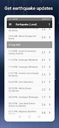
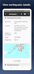
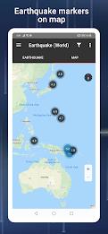
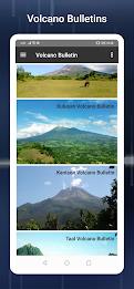
Earthquake, Tsunami, and Volcanic Activity Updates: Get the latest from PHIVOLCS on earthquakes, tsunamis, and volcanic activity. With timely alerts, you can stay safe and informed during natural disasters.
Monitoring Tools: Utilize an array of monitoring tools including Doppler, stream gauge, rain gauge, tide level, and weather station sensors. Keep track of changing weather conditions right where you are.
Hazard Maps: Access comprehensive hazard maps for floods, landslides, and storm surges. Easily pinpoint high-risk areas to plan your travel or evacuation routes effectively.
Emergency Tools: Be ready for any emergency with essential tools like a flashlight, strobe light, siren, and compass. Have a reliable set of tools right at your fingertips.
Additional Features: Dive into additional features such as MT Satellite images and videos, Ovitrap (dengue) reports, government Twitter updates, a listing of critical facilities, and a moon phase calendar.
Conclusion:
Stay ahead of the game with the PH Weather And Earthquakes app. Get real-time weather updates, instant earthquake alerts, and crucial volcanic activity reports. With a suite of monitoring tools and detailed hazard maps, you can stay safe during natural disasters. Equip yourself with essential emergency tools and explore additional features for a comprehensive experience in weather and disaster preparedness. Download the app today and be one step ahead of unpredictable weather conditions and natural calamities.