


ShipAtlas by Maritime Optima

 |
Latest Version | 5.0.0 |
 |
Update | Mar,19/2025 |
 |
OS | Android 5.1 or later |
 |
Category | Productivity |
 |
Size | 156.09M |
| Tags: | Productivity |
-
Latest Version
5.0.0
-
Update
Mar,19/2025
-
 Developer
-
OS
Android 5.1 or later
-
Category
Productivity
-
Size
156.09M


 Download(5.0.0)
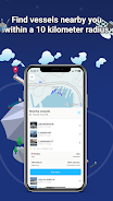
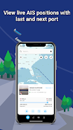
ShipAtlas, developed by Maritime Optima, is an indispensable tool for anyone involved in vessel tracking or maritime activities. Leveraging real-time AIS position data from over 700 satellites and terrestrial sources, ShipAtlas provides unparalleled insights into global maritime operations. Track vessels, analyze trade patterns, monitor port activities, chart sea routes, assess marine weather and ice conditions, identify piracy zones, and explore detailed marine maps—all within a single, powerful application. The app continuously collects and processes raw AIS data for the global merchant fleet, ensuring high-quality, reliable information every second.
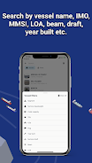
Beyond simple tracking, ShipAtlas empowers users with sophisticated search capabilities, allowing for precise vessel identification by name, IMO or MMSI numbers, or port details. Refine your search further using vessel specifications like length, beam, draft, and year built. Plan voyages efficiently with the integrated sea route calculator, estimating time of arrival, distance, time at sea, and even projected fuel consumption. Create and manage unlimited custom vessel lists, tracking their movements in real-time on the interactive map. Stay informed with daily marine updates and benefit from seamless data synchronization across your devices. A dedicated support chat ensures prompt assistance whenever needed.
Features of ShipAtlas by Maritime Optima:
- Comprehensive Maritime Intelligence: Access real-time data on port activities, sea routes, marine weather, ice conditions, piracy zones, and detailed marine maps.
- High-Quality Data Assurance: Benefit from rigorously processed and verified AIS data, ensuring accuracy and reliability.
- Advanced Vessel Search: Efficiently locate vessels using name, IMO/MMSI numbers, port details, and specific vessel specifications (LOA, beam, draft, year built).
- Sea Route Optimization: Utilize the built-in sea route calculator to estimate arrival times, distances, at-sea time, and fuel consumption.
- Customizable Vessel Tracking: Create and manage unlimited vessel lists, monitoring their real-time positions on the map.
Conclusion:
ShipAtlas by Maritime Optima offers a user-friendly interface and a wealth of real-time AIS position data, coupled with comprehensive tracking and trade information. Its intuitive design, powerful features like the sea route calculator, and commitment to high-quality data make it an invaluable asset for maritime professionals and enthusiasts alike. While many features are available for free, a paid subscription unlocks even greater functionality. Download ShipAtlas today and unlock the power of global maritime information. Learn more on our website.
-
 MaritimeMikeGreat app for tracking ships! The real-time AIS data is super accurate and the interface is user-friendly. I've been using it for my logistics work and it’s saved me a lot of time. Highly recommend for anyone in shipping or maritime fields. 5 stars! 🚢📊
 -
MaritimeExplorerShipAtlas is an incredible tool for anyone in the maritime industry. The real-time tracking and detailed data from over 700 satellites are just phenomenal. It's a must-have for vessel tracking and maritime operations.
-
航海探秘者ShipAtlas 是海事行业中任何人的不可或缺的工具。来自超过700颗卫星的实时跟踪和详细数据真是太棒了。对于船舶跟踪和海事操作来说,这是必备的。
-
ExplorateurMarinShipAtlas est un outil incroyable pour quiconque dans l'industrie maritime. Le suivi en temps réel et les données détaillées provenant de plus de 700 satellites sont simplement phénoménaux. C'est un must pour le suivi des navires et les opérations maritimes.
-
NavegadorMarítimoShipAtlas es una herramienta increíble para cualquiera en la industria marítima. El seguimiento en tiempo real y los datos detallados de más de 700 satélites son simplemente fenomenales. Es imprescindible para el seguimiento de buques y operaciones marítimas.
-
SchiffEntdeckerShipAtlas ist ein unglaubliches Werkzeug für jeden in der Schifffahrtsindustrie. Die Echtzeitverfolgung und die detaillierten Daten von über 700 Satelliten sind einfach phänomenal. Es ist ein Muss für die Schiffsverfolgung und maritime Operationen.